[ Home ] [ Memorial ] [ Writings ] [ Photo Album ] [ Links ]
DELEGATION OF POWERS AND RESPONSIBILITY FOR COORDINATION
Although there is not now a "state land use plan", there are many state-established powers to control land use. The basic power to control land use rests with the Legislature. Principal devices include purchase of land, purchase of easements for specified purposes, and regulation through zoning, permits, subdivision requirements, or other specific perfomance rules.
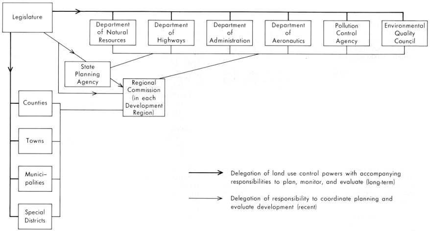
Historically the Legislature has delegated land use control powers to specialized state agencies, general-purpose local governments, or special-purpose districts (Figure 6).
It has long been apparent that some problems and issues overlap the concerns of more than one agency or the areal jurisdictions of more than one local government. Hence, as the delegation of powers has been attenuated to agencies and local bodies, there has been an accompanying increasing need to coordinate the resulting decentralized decisions and policies wherever they transcend the boundaries of local governments or special-purpose agencies. Delegation without coordination would be a recipe for chaos.
In the land use field some of these transcendent regional, statewide, or inter-agency problems have become so obvious and pressing that action has been taken to recognize more clearly the responsibility for coordination and to delegate some of that responsibility to agencies newly-created to do the job.
Perhaps the earliest coordination role was played by the Minnesota Resources Commission (formerly the Minnesota Outdoor Recreation Resources Commission) of the Legislature. This joint commission of both houses was established by the Omnibus Natural Resources Act of 1963. (Ch. 790). A decade ago, through a series of reports, the Commission called attention to the need for standardization, coordination, and expansion of a wide variety of data collection, analysis, planning, and monitoring activities. A number of MORRC reports - issued from 1964 to 1967 - led to the initiation of programs and enactment of laws which have become basic elements in the evolution of state land use planning in Minnesota. Many of the findings and recommendations are still worthwhile reading. Probably the most basic, for development of land use data and policy, were the seven grouped below under three familiar headings:
| Organization | ||
| Report No. 13 | Planning in Minnesota | |
| Data Development | ||
| Report No. 7 | Mapping | |
| Report No. 8 | Hydrologic Studies | |
| Study Report No. 3 | Land Ownership | |
| Critical Areas | ||
| Report No. 2 | Historic Sites | |
| Report No. 11 | Wildlife Lands (Wetlands) | |
| Study Report No. 11 | The St. Croix River |
The report on Land Ownership, published in 1965, was the first attempt to tabulate the amount of land owned by individual federal, state, and county agencies in each county of the state. The report was a milestone, although it was mitigated by the lack of available consistent measurements of land or water areas of the counties and other inconsistencies or gaps in the data.
In 1970 the Lakeshore Study, supported by MORRC's successor - the Minnesota Resources Commission - revealed for the first time the actual use of Minnesota's lakeshore; tabulated for the first time the rate and location of development; showed how much more shoreland the public owns, its location, its quality, and the agency that administers each parcel; provided the initial data base to administer the new Shore-lands Zoning law.4
- 37 -
Figure 6. Diagram portraying 1) delegation of land use control powers from the legislature to specialized state agencies, general units of local government, and special districts and 2) delegation of coordination responsibilities to the State Planning Agency and Regional Commissions.
- 38 -
The Lakeshore Study demonstrated clearly the great potential utility of data on land resources, use, and ownership when those data are consolidated and standardized from the disparate records of many different agencies and levels of government to whom the legislature has delegated powers. But it showed just as clearly the vast amount of interagency coordination and technical work which lay ahead if we were to describe the land use situation, let alone prescribe, monitor, and evaluate changes.
With the support of the Resources Commission, legislation emerged creating both the State Planning Agency in 1965 and the Regional Development Commissions in 1969.10 To those agencies the Legislature delegated wide responsibilities to coordinate land use planning and evaluate land development. With the State Planning Agency as coordinator, several state departments - notably Administration, Natural Resources, and High-ways - have joined the Planning Agency in supporting expansion of the lakeshore land data system to make the first state-wide land use inventory (1969-71), then to launch the long-range development of the Minnesota Land Management Information System.11 At the same time, the Legislature has further specified and delegated coordination and evaluation responsibilities through the laws creating the Environmental Quality Council (1973, Ch. 342) and giving it authority to implement an Environmental Policy (1973, Ch. 412), to control Power Plant Siting (1973, Ch. 591), and to recommend designation of Critical Environmental Areas (1973, Ch. 752).
Figure 6 shows schematically the relationships which have evolved - the coordinating roles of the State Planning Agency and the Regional Commissions.
In the perspective of recent history, these newly-created agencies are only in the initial stages of the vast, long-overdue task of identifying and coordinating the extensive land-use control powers which have been created and dispersed through many different units of government in the past (see Table 18). The structure in Figure 6 is simple and straightforward. Equally important, it is consistent with the fundamental fact that land use plans, developments, and regulations involve almost every agency and every level of government.
Meanwhile, regardless of how much or how little delegation of power there might be, and regardless of the structure devised, the same continuing flows of data and analysis are needed for coordinated planning, monitoring, review, and evaluation. Within a wide range of alternatives, the basic solution to land use problems is largely independent of the way in which powers are delegated or structured. The key is in knowing who is doing what to the land where, what the trends are, and why.
10 These laws are summarized in the following publications of the Minnesota State Planning Agency, St. Paul: Minnesota Planning Legislation. January, 1972. Regional Planning Legislation in Minnesota, November, 1973.
11 George W. Orning and Les Maki, Land Management Information in Northwest Minnesota: the Beginning of a Statewide System, Minneapolis: University of Minnesota Ceniter for Urban and Regional Affairs, 1972. Report No. 1, Minnesota Land Management Information System (MLMIS).
- 39 -