[ Home ] [ Memorial ] [ Writings ] [ Photo Album ] [ Links ]
INDICATIONS OF THE TASK AHEAD
ILLUSTRATIONS OF NEED
There are numerous illustrations of the potential value of an accurate perspective on land use problems and issues. Five cases are highlighted in the following section.
Land for Metropolitan Expansion
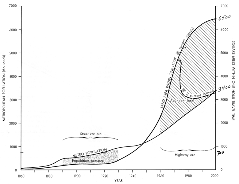
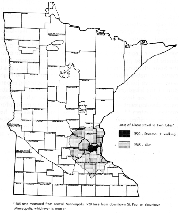
In the Twin Cities area, the Current Land Inventory for Urban Development has grown explosively in the automobile era (Figure 7). In 1920 less than 300 square miles of land lay within one hour's travel time, by street-car-walking combination, from either of the two downtown districts. By 1985, given projected completion of the freeway system and auto-mobile travel speed of the early 1970s, 6000 square miles would lie within one-hour travel time of the center of metropolitan population, southeast of downtown Minneapolis. Accessible land would have multiplied twenty times while metropolitan population multiplied a little more than three times.
Figure 8 shows the changing relationship between accessible land and population. The accessible land, defined as the area within one-hour travel time, includes the Urbanized Area and the Current Land Inventory for Urban Development, as defined in Table 8.
During the years from 1880 to 1920 there was slowly increasing population pressure for density) as the number of metropolitan inhabitants grew relatively faster than the Current Land Inventory and Urbanized Area (Figure 8). A reversal began while the nation was preoccupied with the Depression and World War II. Growing abundance of land brought with it softening of the land market in the central area and related problems of migration, accelerated obsolescence and depreciation, blight, renewal, clearance, and loss of tax base. The Current Land Inventory includes areas far beyond the seven-county domain of the Metropolitan Council, in the surrounding Development Regions Seven-East, Seven-West, and Ten.
Figure 7. Enlargement of the Twin Cities' current land inventory for urban development in the automobile era.
- 40 -
Figure 8. Changing relationship between the Twin Cities metropolitan population and supply of land.
- 41 -
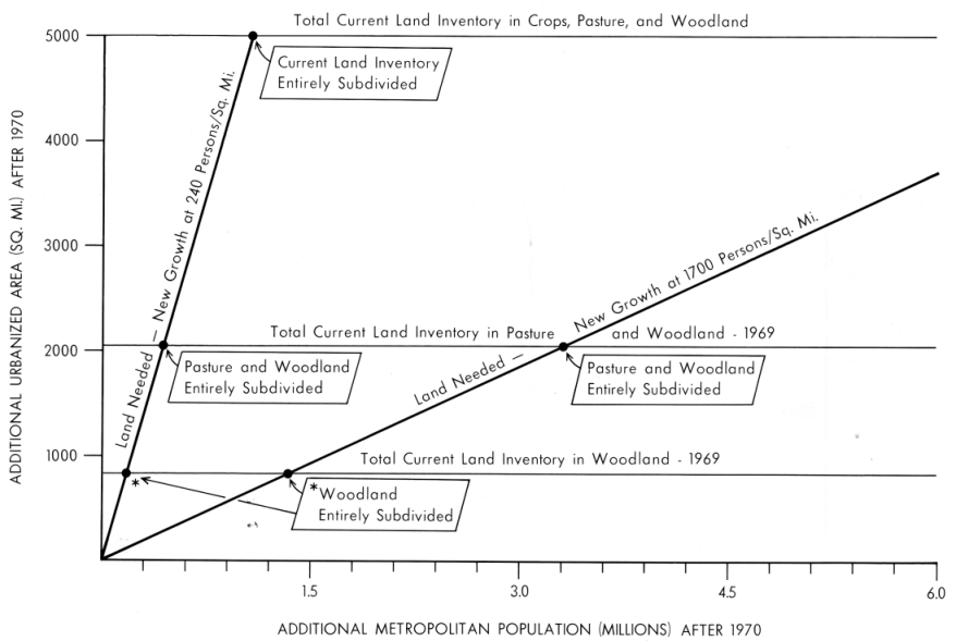
Figure 9. Land needed to accommodate future metropolitan population, at different densities, compared with the supply of land within the Urban Land Value frontier (area shown in Figure 7).
- 42 -
Figure 9 indicates the population growth and length of time required to urbanize the abundance of land in the Current Inventory. At comparatively low suburban densities averaging 1700 persons per square mile, the Current Land Inventory would not be exhausted until metropolitan population reached 9.5 million (more than three centuries at the current absolute growth rate). On the other hand, at a gross density of 240 per square mile, or about eight acres per dwelling unit, the Current Inventory would be exhausted by the next 1.2 million population increase, or in the next thirty to forty years. In fact, the next 300,000 increase (one decade) could result in subdivision of all the woodland and half the pasture in the Current Inventory. To be sure, the subdivided parcels would be large acreages or estates, and the density would be very low. Thus, there is no threat of a physical land shortage, but the traditional rural ownership pattern may well be thoroughly fragmented in another decade or two, greatly increasing the difficulty and cost of acquisition of large tracts for any purpose.
The abundance of land for development will continue into the foreseeable future according to available projections of travel time and real income. However, if a smaller per capita energy supply produced a permanent thirty-percent reduction in average highway speeds, this would reduce the land within one-hour's travel time by nearly one-half (Figure 8). In that case, population pressure would increase sharply as the metropolitan area reverted by the end of this century to the population-land relationship of the pre-World War II years. The result would be a pattern in which (1) the new development areas are more nearly contiguous with the established urbanized mass of the Twin Cities and (2) more concentrated at the edges of a few main satellite employment centers.
The satellites generally lie outside the seven-county Metropolitan Council planning region, in the jurisdiction of the "Rural" Development Regions. Since much of the supply of available land in a situation of continuing abundance also lies outside the seven-county area, the neighboring Regional Development Commissions face the same issue as the Metropolitan Council - spread settlement or major centers. The latter choice seems both likely and wise.
But the question is: Among the many possible locations, which ones have high priority for development? And there are further questions. At any given location, which are the suitable sites? If virtually all of today's Current Land Inventory is likely to be cut into small privately-held acreages by the end of the century, which areas should be obtained by the public in the interim? A forty-year program of acquisition could pro-duce a half-mile wide recreational-trails corridor entirely around the metropolitan area. An afforestation program started now could produce 1200 square miles of additional mature forest by the time the existing forest land is subdivided and developed. Such programs might be carried out for three or four cents per hundred dollars of personal income in the metropolitan area. If they were proposed for specific areas, how would state, regional, and local planning bodies evaluate the proposals?
Land for Electric Power Production
Other illustrations are provided by the need to allocate land for high-nuisance, heavy industries. For example, a conservative projection of the need for new electric power generating facilities would call for ten plants, with total land requirements of 35,000 to 70,000 acres, including the genera-ting stations, substations, cooling facilities, water and fuel storage areas, and surrounding buffer zones.12 That is equal to twelve to twenty-five percent of the total area of floodplains in this state on the Minnesota and Mississippi rivers below Ortonville and St. Cloud, and these large generating plants have been located traditionally along the main streams because of their very large cooling water needs. These numbers indicate the need for a system of priorities in land allocation on the floodplains in the major power market area of the state, or a search for alternate locations.
12 The Impact of Future Electrical Power Requirements on the State of Minnesota, Center for the Study of Local Government, Collegeville, Minnesota: St. John's University Center for the Study of Local Government, January 1971.
- 43 -
Table 14 - Comparison of Selected Features in the Local Environment Which Would Be Affected by Alternative Locations of a Major Power Plant - First Seven Were Considered by EQC Task Force
| Proposed Power Plant Site |
Percent of All County Forest Land within the Local Twp.1 |
Percent of All County Cropland within the Local Twp.1 |
Dwelling Units within Given Distance of Site (miles)2 |
|||
| 1 | 2 | 6 | ||||
| NSP Sites Considered by EQC Task Force |
Cannon City Henderson Jordan Kasota Nicollet Stearns Welch |
40 31 17 3 24 5 8 |
29 4 6 4 22 3 4 |
14 12 19 24 13 10 10 |
42 36 48 77 33 55 35 |
536 400 471 763 302 462 405 |
| Aitkin Co. | 2 | 1 | 6 | 13 | 80 | |
1 From MLMIS land use data, tabulated by Bradley Larson.
2 Data on first seven sites from Northern States Power Company Fossil Fueled Power Plant Siting Study, Vol. I, Jackson, Michigan: Commonwealth Associates, 1972. Aitkin County data from 1969 aerial photography, by Bradley Larson.
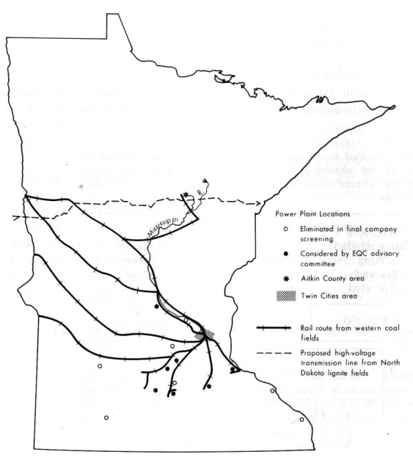
The most recent case of a search for a suitable location involved the Northern States Power Company plant to be constructed next after the new Sherburne plant at Becker (Figure 10). Fifteen alternative sites survived the first screening by the company, and seven were finally passed along to the State Environmental Quality Council, with one to be selected.13 All of the seven lay within, or very near, the Twin Cities commuter zone (Current Land Inventory) and within the main cropland region of the state. The search area was also within the most populous part of the state. Most of the seven recommended sites were in tributary valleys along the Mississippi or Minnesota rivers. They preempted scarce scenic relief and forest land in the part of the state that is almost all open, cultivated plains. And where a recommended site was on the open, upland plains, it overran prime agricultural land.
The metropolitan commuter region has no schedule of locational priorities or site suitability rankings - no plan - for accommodating these large installations which have traditionally been located relatively near the big urban markets. Nor have there been statewide priorities or suitability rankings, such as those to be provided by the state's new power plant siting program in the State Planning Agency, for alternative places outside the metropolitan commuter region.
One such alternate possibility is in north central Aitkin county, in the basin of the Willow river. As Figure 10 indicates, the location is only slightly farther from the Twin Cities market than three of the fifteen sites which survived the first screening by the power company, and slightly closer to the source of coal supply than all but one of the seven final choices.
The potential Aitkin County site, compared with the seven which were considered, scores very much more favorably on environmental impact measures which were used by the power company consultant (Table 14). The site is on a post-glacial lake bottom; therefore flooding the land to create a reservoir, rather than desecrating the area, would be restoring it to what was once its natural condition.
13 NSP Fossil Fueled Power Plant Siting Study, Jackson, Michigan: Commonwealth Associates, 1972, Volume I - Inventory.
- 44 -
Figure 10. Locations of fifteen highest-priority sites considered for the next major power plant construction by the Northern States Power Company, 1972.
A reservoir could be created large enough not only to meet the needs of much additional future power generation but also to hold in reserve perhaps half a year's water supply for the Twin Cities. That would be timely. For studies have indicated that by 1980 the one-year-in-thirty low flow of the Mississippi at the Twin Cities intakes will be less than the daily requirements; and some supplementary source will be needed which does not destroy the recreational values of the headwaters lakes.14
A new high voltage transmission line from the North Dakota lignite fields to Duluth is projected to pass through the area.
Finally, of about 71 square miles in potential reservoir site, 61 square miles are already in public ownership. The area comprises about 7 percent of all of the forest-marsh land use combination in the state. Hence if the site's wetland and forest/ habitat were damaged, many alternative locations exist. Furthermore, no alternative might be needed, for it is possible that flooding would actually enhance the Aitkin county wild-life habitat, not destroy it.
In short, while a comprehensive study might possibly show the Aitkin County site to have a low priority and suitability ranking for reasons not apparent here, examination of the site suggests that somewhere there may be an opportunity for the state - as planner and large land-owner - to lead in the development of power generation parks which would minimize both environmental impact and nuisance to populated areas.
Land for Increased Commercial Forestry
Table 15 compares the state's present area of forest land with the commercial forest acreage potentially required for logging by the mid-1990s. Assume that areas of scenic relief, recreational lakeshore, and mining are excluded from the forest land available for logging.
14 Minnesota Water and Related Land Resources: First Assessment, St. Paul: Minnesota State Planning Agency, 1970, pp. 127 and 373.
- 45 -
It appears that there will be a slight deficit of available commercial forest by the end of the century. Logging, residential, and recreational interests could be in economically serious competition for scenic relief and lakeshore lands. Yet there are 800 thousand acres of pasture and open land within the forest region. Much of that open land is potentially more productive for timber than some of the land now logged, and it has long been submarginal for field crops.
It appears that there could be a rational allocation of scenic and lakeshore land in the forest region, and expansion of the commercial forest into presently open areas based on priority locations and site suitability rankings. Designation of these areas may well affect plans for public afforestation, local highway construction, and maintenance of school districts. And it will enable state, regional, and local agencies to evaluate proposals and balance counterproposals which will come from both preservation advocates and loggers.
Table 15 - Available forest land, compared with area potentially required for logging by mid-1990's. Available land for logging excludes present forested areas with scenic relief and lakeshore, and it considers additional land which could be reforested. It is clear that there will have to be rational allocation of scenic and lakeshore forest lands in an era of full utilization of the nation's timber resources.
| Total Forest in Forest Region 1969 |
Scenic Relief, Lakeshore, and Mining Land Potentially Excluded from Logging |
Present Open and Pasture Land Potentially Reforested |
Available (Non-excluded) Area Presently Forested |
Available Forest Area Plus Potential Reforestation |
Required Forest Land |
| 15,081,000 | 6,763,000 | 800,000 | 8,318,000 | 9,118,000 | 8,600,000 |
Note:
"Forest Land" consists of all 40-acre parcels more than 10% covered by tree crowns. "Forest Region" is the area of the state in which contiguous Minor Civil Divisions have more than 43% of their parcels in Forest Land. "Scenic Relief" area is defined as all land in any Minor Civil Division in which one-third or more of the MCD has at least 100 feet of "Local Relief" (i.e., 100 feet difference in elevation in a mile-square section). "Lakeshore" area is defined as all land in any MCD in which at least six percent of the MCD is. jn water surface, plus all non-urban parcels adjoining Lake Superior. "Mining Land" is the maximum estimate for both iron and copper-nickel from Table 16. Tabulated from MLMIS land use data by Scott Dixon and John Borchert.
"Required Forest Land" figure represents the acreage required to meet projected cut in year 1992 from both hardwood and softwood growing stock on a sustained yield basis. Projected timber cut from A Third Look at Minnesota's Timber, U.S. Forest Service Resource Bulletin IMC-1, 1966. Acreage calculations based on medium site rotation ages and volume data for aspen and jack pine. Rotation and volume data from Ranger District Forest Survey Manual, Minnesota Department of Conservation, Division of Forestry, 1960. Total required acreage =
![]()
Research and calculations by John Shea.
- 46 -
Table 16 indicates the amount of land needed for mining in northeastern Minnesota between now and the end of the century, compared with the total forest land resource. It appears that proposals for mineral expansion will be under frequent discussion, especially if low grade copper-nickel ore production comes into the picture. Possible location of new mining is obviously restricted to the mineralized areas. Within those areas, it is incompatible with logging and recreational use of the forest. On the other hand, if the total land committed to mining is relatively small, and the forest area relatively large, land allocation, or zoning, could still provide ample land elsewhere for other uses.
The table shows that the next three decades could see almost as much land affected by copper-nickel mining as the entire area affected by iron mining since the industry began more than 80 years ago. But the iron mining picture is also changing, with the shift to low grade ores. Hence the acreage affected by iron mining in the next thirty years could well increase by two and one-half times.
In perspective it appears that the entire enterprise could consume 12 to 14 percent of the forest land (outside and excluding the Boundary Waters Canoe Area wilderness portion of the Superior National Forest) of the four northeastern counties - a significant share. It would likely use only about two percent of the total forested land within the Forest Region of the state (Figure 1). There appears to be plenty of land, in the simplest sense, to accommodate the major competing activities and preservation needs. But priorities could well be set for expansion of the mining zone, location of related industrial zones which will require port facilities, priorities for open space preservation and recreational development, and environmental performance standards for the mining and industrial zones.
Floodplain Use
Table 17 shows the use of floodplain lands. Two points stand out. First, the floodplain acreage is a minute fraction of the state's land resource. The total floodplain land on these major reaches of river is less than half of one percent of the state. Within the metropolitan commuter zone, undeveloped floodplain lands represent less than two percent of the total undeveloped land. Thus there appears to be no justification for zoning floodplains for any uses which do not require immediate access to water transportation.
Table 16 - Land Needed for Mining Compared with Total Forest in Northeastern Minnesota - Excludes Boundary Waters Canoe Area*
| Mining Land1 | Forest Land2 | Mining Land as Percent of Forest, Year 2000 |
||||||||
| Iron | Copper Nickel | 4 NE Counties |
Forest Region |
|||||||
| 1969 | 2000 | 1969 | 2000 | 4-County | Forest Region | |||||
| Min | Max | Min | Max | Min | Max | |||||
| 88,000 | 228,000 | 0 | 26,000 | 76,000 | 2,151,000 | 14,217,000 | 12 | 14 | 2- | 2+ |
Notes:
1 Estimates by Pamela Streed based on output projections from First Annual Report of the Secretary of Interior under the Mining and Metallurgy Policy Act of 1971, Washington: U.S. Government Printing Office, 1971, Appendix I: information on land requirements and production characteristics of typical mines from Mr. Elwood Rafn, Minnesota Department of Natural Resources; and from MLMISdata on Mining land use on the Mesabi Range.
2 From MLMIS land use data.
* Land area in thousands
of acres.
- 47 -
Table 17 - Use of Floodplain Lands Along Approximately 760 Miles of River Frontage - Tabulated from MLMIS Land Use Data by Leland Comb
| RIVER CORRIDOR |
Total Acres |
FLOODPLAIN LAND | ||||||
| Percent of Total | ||||||||
| Forest | Crop | Open | Marsh | Lake | Urban | Sum | ||
| Minnesota River Ortonville to Metro Mississippi River St. Cloud to Iowa except Metro Mississippi, Minnesota, and St. Croix in 7-county Metro |
113,080 96,160 65,000 |
25 30 2 |
29 9 12 |
17 9 18 |
3 6 7 |
18 40 25 |
8 5 16 |
100 100 100 |
| TOTAL |
274,240 |
|||||||
Second, uses which do require water transportation require a very small fraction of the total floodplain land resource. For example, a controversial coal storage and dock facility pro-posed for St. Paul, if it used 600 acres of land, would utilize about two-tenths of one percent of the floodplain lands surveyed, about half of one percent of the floodplain lakes and wetlands. It may well be that there is room somewhere on the floodplain for the proposed facility.
The questions are: What are the priority locations for this kind of use and the priority locations for preservation and for other competing uses; and in those locations, what are the prime sites?
The same questions would stand if there were a proposed expansion of the coal facility to something approximating the present capacity of the port of Toledo, Ohio, or other
proposals to build massive plants to gasify the coal.
Summary
Minnesota has a very large and varied land resource. How-ever, exceedingly large needs are emerging in very large pack-ages, as a result of greatly increased scale of both management and technology. To be sure eventually there may be no incompatible land uses; it may be possible to eliminate all environmental nuisances and hazards at the source, or to screen all aesthetic abominations. Those are goals with which no one will disagree. But for a protracted interim period that goal is likely to be elusive. Technology will be imperfect. Incompatible uses will continue to be with us; the problems they cause will cover ever-widening areas; and prescribing land use configurations will continue to be the only practical remedy.
In other words, there will be increasing need to allocate land among major uses to avoid blight and resource destruction on an unprecedented scale. This will require zoning on a new scale, with allocation of land based on the best available understanding of location and site.
MILESTONES OF PROGRESS
If events are driving toward statewide, large-scale zoning and land allocation based on the best and most widespread possible understanding of location and site conditions, two questions then arise. What is our ability to describe the present situation, to provide the factual basis for development of a statewide plan? And what is our present ability to regulate, monitor, and evaluate performance in accord with a plan?
- 48 -
Ability to Describe the Situation
The first detailed land use survey of Minnesota, on which much of the substance of this paper is based, was published in 1971. The study was based on 1969 high-level aerial photography, flown during a brief period for the entire state. Standard definitions and land use classes were applied over the whole state, and care was taken to make the application of those definitions and classes as nearly uniform as possible. For the first time, the amount of land in each major use could be measured for small areas, compared and summarized state-wide, and mapped in detail. But that is still possible for only one point in time. The survey should be repeated, ideally in 1974, five years after the first survey, and contemporaneous with the five-year census of agriculture.
Only then will the state begin to build up a time series of land use data and begin to have the ability to measure trends, forecast, and interpret observed and projected changes.
Meanwhile, one might expect that inventories and plans already prepared for individual counties could be combined to make a statewide picture of existing and projected land use. Table 18 and Figure 11 reflect a common problem
encountered in any attempt to build a regional or statewide description of resource use from the collective work of either different local governments or different state or federal agencies. That is the problem of non-comparable terms and measures.
Table 18 was compiled from forty-six county plans on file at the State Planning Agency.15 The table covers forty-two of those counties, whose plans were prepared under contract by five different consulting firms. The plans are compared for their use of terms to describe the most straightforward and fundamental classes of land use. None of those uses is absent in any of the counties. Yet it is apparent that they are not identified in any discrete or consistent way. There is lack of consistency from one county to another on the part of the same firm, and it is apparent that the counties were not concerned with coordinating either their surveys or their resulting projections with those of their neighbors.
Table 18 - Tabulations from a Survey of Forty-Six County Plans on File at Minnesota State Planning Agency, Prepared by Nine Different Consulting Firms - Compiled by James Alders and Robert Borchers, 1973
| Consulting Firm |
Counties Planned |
Number of Counties in which Given Land Use Category is Designated in Plan |
|||||
| Urban Res. Or Residential |
Commercial | Industrial | Recreation, Park, Green Belt, Public |
Agric. | Urban | ||
| A B C D E |
4 12 7 14 5 |
3 2 3 5 3 |
2 6 5 5 4 |
3 6 5 5 4 |
4 8 2 8 5 |
3 2 0 4 1 |
1 8 2 0 0 |
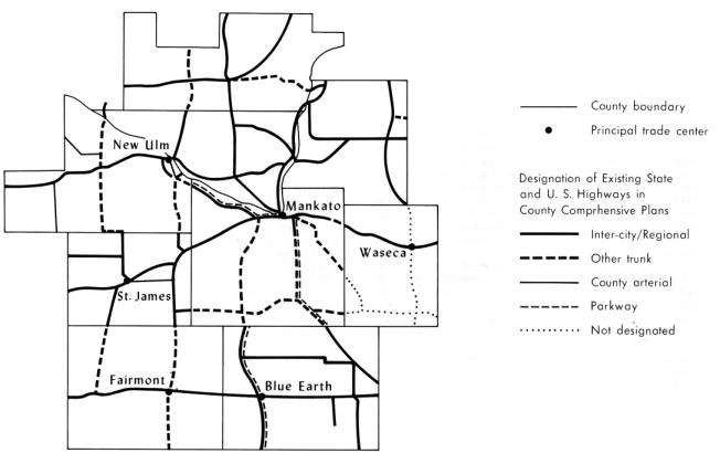
The map in Figure 11 compares the roads in the existing state and federal highway system, as they are designated in comprehensive plans, for nine counties in south-central Minnesota. These roads comprise a regional highway network. Yet, coordination of planning among counties appears to have been difficult. The roads cross county boundaries at twenty-two points; and there is a discontinuity in classification of the road at sixteen of the twenty-two crossings. These discontinuities in functional classification of the road would logically be accompanied by discontinuities in the level of road improvement, road maintenance, and related land uses.
Some of the inconsistency results from attempts by the consultants to make the terms used in their surveys and plans coincide with the terms used in the particular county's zoning ordinance. That simply indicates the even greater depth of the problem; the official zoning categories and ordinances also form a crazy-quilt.
The Regional Development Commissions now provide the machinery to coordinate planning and evaluation across county boundaries and to help bring consistency into this kind of information about the land.
15 James Alders and Robert Borchers, Land Use Control at the County Level, MLMIS Technical Memorandum No. 1, 1973 (mimeographed).
- 49 -
Figure 11. Designation of existing state highways on comprehensive plans of nine contiguous counties in south-central Minnesota. Note the relatively large number of discontinuities in functional class of road at county boundaries. Data from county plans on file at State Planning Agency.
- 50 -
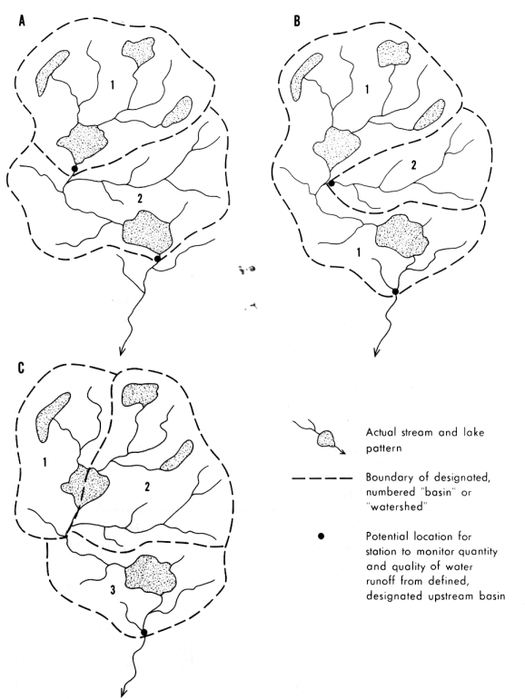
Figure 12 illustrates another dimension of the problem. It shows three different ways in which the same actual pattern of streams and lakes could be divided into drainage basins (water-sheds). In other words, the problem is to delineate drainage basins on this piece of the surface of Minnesota, and these are three different solutions to the same problem. The explanation under Figure 12 indicates that one of the three solutions (B) is inferior and another (C) is useless. Yet all three types of solution actually appear on existing drainage basin maps of state and federal agencies in Minnesota. As a result, even if the network of stream monitoring stations were large enough to provide a detailed picture of water quantity and quality, it would not be possible to relate the water information to land use data in some local areas because the local drainage basins have not been delineated in such a way that the flow of water from them can be measured and related to the use of land within them. Meanwhile, there has been no designation of an official stream or drainage basin map of the state. All of these problems are mutually reinforcing. Yet laws and reports call for coordination of water resource plans and land use plans. These problems are now likely to be faced as a result of 1973 legislation to initiate a statewide water information system.
Ability to Regulate
One finds somewhat similar problems emerging from an exploration of land use regulation. While new land use regulations are under discussion it appears that we have only a hazy picture of what can be accomplished or is being accomplished with existing powers. Table 19 summarizes a compilation of existing powers, which the legislature has delegated to various state agencies, to control land use. The number exceeds seven hundred, and it might be useful to know what could be done if these were applied in a coordinated way, and what agencies would have to coordinate which of their efforts in order to carry out the task. Mapping of the land areas subject to a very limited sample of these powers in Pope county has shown that about two-thirds of the area of the county is subject to one or more existing state land use controls. Indexing of these powers and mapping of them in selected pilot locations is part of the current work program of the Minnesota Land Management Study.
Figure 12. Three different delineations of drainage basins (watersheds) for the same given pattern of streams and lakes.
Delineation A: Stream monitoring points are evenly distributed along the main stream; each point permits monitoring the quantity and quality of water from a discrete land area, and the areas are similar in size.
Delineation B: Monitoring points are evenly distributed; but areas monitored are of greatly different size.
Delineation C: None of the basins delineated can be monitored from a single station at the basin outlet. Observations at the outlet of Basin Number 3 would actually monitor combined flow from all three "basins"; hence the delineation is of no use.
Each of these three types of watershed delineation actually appears in the existing drainage basin maps of Minnesota. Types A and B are most common.
- 51 -
Table 19 - Powers of Minnesota State Agencies to Control Land Use1
| Powers | Agencies and Departments | |||||||||||
| Natural Resources |
Administration | Highways | Pollution Control |
Aeronautics | Environmental Quality Council |
State in General |
Local Government Units2 |
Totals | ||||
| ACQUISITION | 44 | 11 | 13 | 0 | 4 | 0 | 10 | 7 | 89 | |||
|
3 8 2 |
0 0 0 |
0 0 0 |
0 0 0 |
0 0 0 |
0 0 0 |
0 1 3 |
0 0 0 |
3 9 5 |
|||
|
41 32 20 |
0 0 0 |
11 1 2 |
16 12 2 |
4 11 1 |
2 2 0 |
3 2 0 |
3 9 2 |
80 69 27 |
|||
|
1 30 15 7 0 |
0 0 0 0 0 |
0 0 0 0 0 |
2 10 1 1 0 |
0 9 0 0 7 |
1 2 0 0 0 |
2 1 0 0 0 |
0 7 1 0 0 |
6 59 17 8 7 |
|||
|
18 20 9 1 3 0 |
3 0 0 1 0 0 |
9 2 1 2 7 2 |
0 0 0 0 0 0 |
0 1 0 0 0 0 |
0 0 0 0 0 0 |
4 4 0 0 0 0 |
2 3 0 0 0 3 |
36 30 10 5 10 5 |
|||
| DEVELOPMENT | 59 | 0 | 33 | 12 | 8 | 4 | 2 | 11 | 129 | |||
| MAINTENANCE | 34 | 0 | 12 | 10 | 6 | 0 | 0 | 20 | 82 | |||
| FINANCIAL ASSISTANCE | 12 | 1 | 31 | 11 | 11 | 1 | 4 | 8 | 79 | |||
| ENFORCEMENT | 16 | 0 | 0 | 7 | 2 | 1 | 1 | 1 | 28 | |||
| TOTALS | 375 | 16 | 126 | 84 | 65 | 13 | 37 | 77 | 793 | |||
NOTES:
1 The following chapters of the Minnesota Statutes were examined in whole or in part [p] : MSA 16[p] , 83[p] , 84, 84A, 84B, 85, 85A, 86, 88, 89, 90, 92, 93, 94, 97, 99, 100[p] , 104, 105, 106[p], 110, 115, 116, 116C[p] , 116D[p] , 116G [p], 117, 160[p] , 161, 162, 167[p],282[p],360.
2 Powers of sanitary sewer districts, which are statutorily regarded as municipal corporations, were included under this heading rather than under Pollution Control Agency.
Table taken from Wayne Gilbert and Douglas Gregor, Minnesota Land Use: A Classification of State Powers, Minneapolis: University of Minnesota Center for Urban and Regional Affairs, 1973 (MLMIS Report No. 5), p. 9.
- 52 -
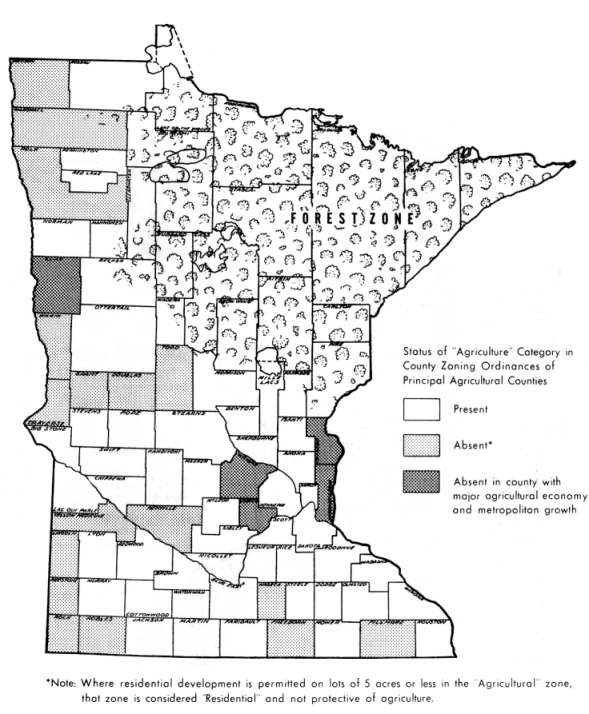
A survey of the seventy-five existing county zoning ordinances seems to indicate another set of inconsistencies. A recent policy recommendation by the Minnesota Chapter of the Soil Conservation Society echoes many previous statements in the same tone: "Prime agricultural land in the state must be permanently and exclusively reserved by land use controls with agriculture recognized as its highest use in both public and private interests." Yet an "Agriculture" category is absent from the zoning ordinances of a large number of counties scattered randomly across the main farming region of the state (Figure 13). Most important, such a zone appears to be absent from several counties which combine an important agricultural economy with severe land development pressures due to Twin Cities metropolitan expansion.
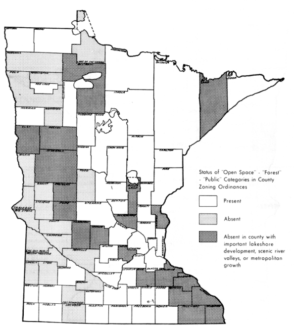
Figure 14 shows that zoning categories which explicitly protect recreational open space are absent from the ordinances of many counties scattered through the lake regions and, most notably, in counties with major lakeshore resources or scenic river valleys under pressure from metropolitan growth and second home development.
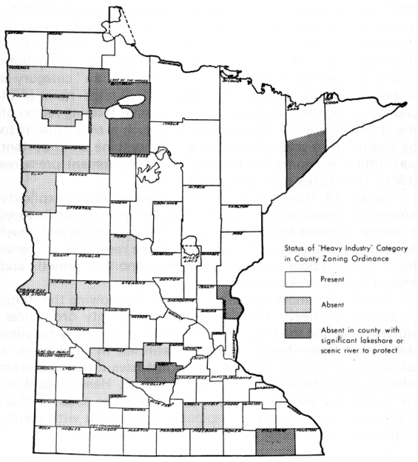
Another example appears in Figure 15, showing the status of zoning for heavy industry among the county ordinances. Notwithstanding the pressure to locate large electric generating stations, or other heavy industrial facilities, in rural areas, a considerable number of counties do not have a zoning system which guides the location of such facilities. Heavy industries are commonly very large water-users; hence the absence of an appropriate zone is most conspicuous in counties with significant lakeshore or scenic river valley lands to protect.
Figure 13.
- 53 -
Figure 14.
Figure 15.
- 54 -
None of these observations is offered in criticism. They are cited as evidence of the large amount of basic technical work which must be completed in order to put substance behind our rhetoric about statewide land use planning, monitoring, and evaluation. As a result of recent legislation and consequent agency work programs (see Table 13, above), a substantial attack on these problems has begun at a number of points in the system.
Coordinated by the State Planning Agency, the Minnesota Land Management Study and a number of state, regional, and local agencies are cooperating to develop the essential informa-tion base - much of it through the integration of disparate data series that already exist.
The work program of the Land Management Study for the current biennium has two major components directed at the basic needs developed in this paper.
| Soils | Highway orientation of land parcels |
| Watersheds | Public ownership |
| Streams | Land use and cover |
| Lake Basins | Geographical coding of locations or sites |
| Water orientation of land parcels |
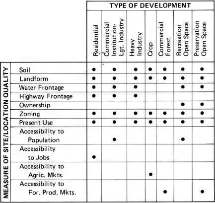
Table 20 indicates the categories of development or preservation for which the land will be evaluated, and it also shows the type of data which will be used in the evaluation.
Pilot studies are now in progress to develop and test the system of land-use suitability and priority classification. These studies are cooperative efforts involving county and regional officials as well as state and federal agencies. The concept of the statewide system and the progress of the pilot studies will be described in detail in a forthcoming report from the Minnesota Land Management Study.
Table 20 - Measures of Site and Location Quality to Be Used to Evaluate Suitability and Priority of 40-Acre Land Parcels for Each of Seven Major Classes of Development (or Preservation)
- 55 -
In view of the current outpouring of land use literature and the possibility of federal legislation to encourage statewide land use planning and controls, it is timely to try to put into perspective the broad land use patterns, issues, and programs in Minnesota.
There is a land utilization system whose physical structure is made up of the regions, sub-regions, zones, parcels, and neighborhoods on the land use map of the state. The structure is altered as the regions change and their frontiers advance or retreat. Parcels change in their marketability, ownership, and use. The process involves familiar actors and actions. Public bodies and agencies are distinguished among the actors by their large amount of responsibility and comparatively small risk of the economic or environmental consequences of their actions. Bystanders - the "general public" - are distinguished by their traditionally small chance to monitor or evaluate changes which affect them until after basic decisions have been made.
Problems arise out of the normal operation of this system. They fall mainly under five headings.
An analysis of the problems indicates four basic remedial actions.
Each of these remedial actions implies (1) widespread information, continuously available, on accessibility and site conditions of all of the land resource and (2) regulations based on that current and widespread information about the land. Government is in the best position to collect and disseminate the information because of the multiplicity of data normally collected in connection with taxing, licensing, and permits. Government regulations based on that information are most likely to be credible, attainable, and subject to monitoring for performance and evaluation.
There are grounds for caution in adopting new powers or further alterations in governmental structure until recently-established bodies have been fully tested. The legislature has delegated many powers to control land use to both specialized state agencies and general units of local government. But decentralization without coordination is a recipe for chaos. Therefore delegation of powers has brought increased responsibility to coordinate the decentralized use of powers. In turn, the need for coordination has gradually emerged, and responsibility, relatively recently, has been delegated to the State Planning Agency and the Regional Development Commissions. The operation of those agencies is making increasingly apparent the need for continuing, standardized data and analysis concerning the status of the land in Minnesota.
A very large amount of technical work lies ahead. How-ever, there is a vast assortment of powers and data series capable of coordinated use. Significant efforts are now under way in state agencies, regional commissions, and local governments to do the technical work that will lead to basic remedies for blight and environmental degradation resulting from misuse of the land.