(p.
3)
Chapter
1
One
Tenth of America's Land
To
most Americans the Northern Heartland
has long been the most mystifying part of their
country. Spreading across the northern states,
in the deep interior of North America, from Montana to Michigan's Upper Peninsula,
from northern Iowa to the Canadian border,
the region contains about one-tenth of the total
land area of the 50 United States. It is as big
as Texas and twice as empty (or half as crowded).
In the western reaches the shopping trade
area of Miles City, Montana, includes
more land than the state of Connecticut;
to the east the local trade area of Bemidji, Minnesota, is almost as large as New York's Adirondack Mountain region.
Billboards on the edges of some small
towns proclaim plenty of room to grow.
They are always at least half-right;
there is plenty of room. In many cases they
are all right; there is also growth, some of it fast by any comparison, some of
it remarkably steady by any
comparison.
If
you fly the scheduled airlines from Seattle-Tacoma
to the Twin Cities, and on to Boston, more than one-third of the transcontinental
trip crosses this region (Figure 1). Coming
from Seattle you could mark the region's western
boundary about where you see the Bear
Paw Mountains rise a half-mile above the plains
of north central Montana. There on a summer day a dark island of ponderosa pine forest
stands above the sage- and grass-covered, deeply carved lower slopes; the whole
mass overlooks the sea of strip-cropped wheat
fields and rangeland that rolls northward into Saskatchewan. As you head
eastward
from the Twin Cities and leave the region,
you could look far to the north of your route
and imagine the boundary where the Porcupine
Mountains rise 1,000 feet above Lake
Superior. Rock ledges tower above Lake of
the Clouds. The glacier-polished rocks and the clear lake are bright openings in
the midst of a dense forest where 17 feet of snow fall in an
average winter. The northern boundary of the
region lies 250 miles north of the Twin Cities
airport. There the Rainy River spills from border
lakes that wash hundreds of miles of quiet,
rocky Minnesota and Ontario shores. In contrast, on the region's southern
edge, 150 miles south of the Twin Cities, the
upper reach of Iowa's Skunk River winds southward between gently undulating, tile-drained corn fields.
From
the Bear Paws to the Porcupines,
from
the Skunk to the Rainy, this region sprawls
over one-third of a million square miles.
What shall we call it? Perhaps the name used most widely and for the longest
period in the
region's short history is Northwest. This was the new Northwest, when the settlement frontier
was advancing across the region from the
1850s to the 1910s. It was mostly distinct from the Old Northwest—the land
east of the Mississippi and "northwest of the River Ohio," defined
by the Northwest Ordinance of 1787. While the
name Northwest was applied from the
outside, it was also adopted by insiders
in St. Paul, Minneapolis, and cities and
towns from western Wisconsin to eastern Montana. With development of metropolitan centers
at Seattle, Tacoma, and Portland, and emergence
of the name Pacific Northwest, Northwest
gradually dropped from vogue in this
interior region. Meanwhile, Central Northwest was tried, then Upper Midwest and
Northland. People from other parts of the United States often vaguely
called it the Northern Plains. Those terms
imply a unity to the region, which
indeed it has. But they also mask its
rich diversity. Because this book is in some ways a sequel to a regional study that used
the term Upper Midwest a quarter-century ago,
I shall use the same term now.1
(p.
4-5)
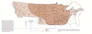 Figure 1. America's Northern Heartland. The primary region of the Upper Midwest reaches from northern Iowa to the U.S.-Canadian border, from northern Wisconsin to eastern Montana. The Minneapolis Federal Reserve banking district and some transportation, wholesaling, and services
extend the region's periphery across Montana and Michigan's Upper Peninsula. The spacing of cities on the map reflects the climatic gradients from the lush, productive Midwestern Com Belt to the colder North and the drier West. The smooth, deep mantle of glacial deposits across much of the heart of the region contrasts with the rougher plains west and south of the Missouri, the glacier-scoured uplands surrounding Lake Superior, and the mountainous western margin.
(p. 6)
Figure
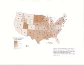
2. Church Membership as a Percentage of Total U.S. Population, 1971.
The Upper Midwest had
one of the highest proportions of church membership
in the United States, along with southeastern New England and the Mormon
West. Source:
note 2.
(p. 7)
The
Ties That Bind
To
those who regularly travel the region, do
business in it, and live in it, this is a big neighborhood,
or an empire, or perhaps both. All over the far-flung area, familiar regional names
mark chain and franchise stores, banks,
and farm cooperatives. Familiar hymnals
from familiar publishers are at hand in the church
pews (Figure 2). (With southeastern New
England and the Utah valleys, this ranks as one of the three most churched areas
in the United States.)
Familiar networks of friends and
relatives, built on the migration patterns of several generations, bridge
between the farms, the
Twin Cities of Minneapolis and St. Paul,
and the intermediate towns and hamlets
. Familiar meetings and conventions come together
most often at Minneapolis-St. Paul. And
everybody shares the concealed satisfaction
of surviving and even prospering in the world's
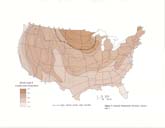
most extreme climate (Figure 3). Hot winds, arctic gales, searing drought,
dripping humidity,
dust clouds, dense fogs, tropical downpours,
tornadoes, chinooks, fence-high snowdrifts,
breath-freezing stillness, baking sun—those
tests of human adaptability occur in
various combinations in every part of the world.
But only in the Upper Midwest can you expect
all of them in the course of any normal year.2
One
measure of neighborhood is who talks
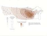
to whom and how much. Telephone connections
provide a measure of that kind of interaction,
and the Upper Midwest is a buzzing hive
of phone messages between places and people
(Figure 4). The contacts have a geographic
pattern. To be sure, there are calls from
everyplace to every other place. But the calls
from farm neighborhoods or hamlets go most
frequently to the nearest shopping and service
center. From shopping and service centers
most frequent connections lead to the nearest
larger centers of wholesale distribution,
services, and shopping. And within the region,
calls from all those places to a large metropolitan
area flow predominantly to the Twin
Cities. In a different way the professional sports
radio networks outline the region (Figure
5). While the breadth and depth of their coverage
has varied with success on the playing
fields, the networks have persistently linked
the localities in which there is enough loyalty to the regional teams to make
the broadcasts
commercially salable in the local markets.3
The
Minneapolis-St. Paul metropolitan area
is one of 30 high-order urban centers in the
geographic structure of America's urban settlement
(Figure 6). Those 30 centers are the home
of nearly two-thirds of all the country's population.
They are the locations of nearly all of
the Federal Aviation Commission's major hub
airports. They are the main concentration of
corporate headquarters, professional services,
arts, and professional sports. Those activities
combine with their skylines to make the
high-order cities the main symbols of metropolitan
America.4
The
primary region of the Upper Midwest is that part of the United States which is
closer to the Twin
Cities than it is to any other high-order
metropolis. The pattern of phone messages
reflects this fact. And what are the messages
about? They undoubtedly reflect the sweep
and diversity and historical evolution of
the region. People are placing orders with wholesale
distributors, transferring payments,
arranging professional services, reserving
seats for games or concerts or foreign tours,
reserving hotel rooms for meetings, catching
up on the affairs of migratory friends and
relatives, and of course talking about the weather.
Sometimes the same call serves several
of those purposes. Thus the Upper Midwest is the primary trade and service
area of the Twin
Cities. The Twin Cities did not make the
region. The region did not make the Twin Cities.
The pattern just evolved in the complex process
of settling the land of the United States.
Some
strong linkages reach beyond this primary
region of the Upper Midwest. The periphery
of the region extends west into the Montana
Rockies-to Glacier Park and Yellowstone,
to the valleys of the Flathead and the Bitterroot. And it extends east across northern
Wisconsin and Michigan's Upper Peninsula to
the rapids of the St. Marys at Sault Ste.
Marie. Phone traffic from smaller towns
and cities in the periphery to the Twin Cities
is less than the flow from those places to Seattle,
Denver, Chicago, Milwaukee, or Detroit.
Yet those smaller places in the periphery are more strongly linked to the Twin Cities than
are other places of similar size outside the region.
The
region's extended periphery largely reflects
Twin Cities banking connections. With
the creation of the Federal Reserve system in 1914, regional Federal Reserve
banks were established at a dozen major cities. Minneapolis
was one because it was the larger of the
twins, and because the Twin Cities metropolitan
area at that time was far larger than any other
western or southern city except San Francisco
and Los Angeles. The national map was divided-into 12 Federal Reserve districts,
each tributary to one
of the system's banks. Then,
as now, a territory existed in which correspondent
ties between metropolitan and local
banks clearly focused on the Twin Cities. The
territory included Minnesota, North Dakota, much
of Montana and South Dakota, and northwestern Wisconsin. Banking ties in much
of that area reflected sheer proximity to the
Twin Cities. In central and western Montana
they reflected the legacy of business connections
along the Twin Cities-based Northern
Pacific and Great Northern railroads. There
were important ties in nearby northern Iowa,
too. But all of Iowa was foregone Chicago
territory in this contest. Without part of Iowa,
the population of the Twin Cities banking region was not quite enough to meet
the minimum requirement; hence more of northern Wisconsin and the Upper Peninsula of Michigan
were added. Metropolitan ties of those areas
then, as now, ran mainly southward to Chicago,
Milwaukee, or Detroit. But an important
flow of commerce also moved east-west along
the original Soo Line railroad, between the
Twin Cities, Sault Ste. Marie, and eastern Canada.5
(p. 8)
Figure
3. Seasonal
Temperature Extremes. Source: note
7.
(p. 9)
Figure
4. Frequency
of Phone Calls to the Twin Cities. Source: note 6. (Detailed data from 1963; intensity
adjusted on the basis of data for 1972 and 1975.)
(p. 10)
 Figure
5. Professional
Sports Radio Stations and Listening
Area, 1983. The broadcast for Twin Cities
professional baseball and football teams has coincided
approximately with the Upper Midwest primary region. Source: Kaufman, note 3.
Thus
an Upper Midwest primary region reaches
from the Bear Paws to the Porcupines and
the Skunk to the Rainy. And a periphery extends
west into the Montana Rockies and east
to Sault Ste. Marie. The primary region and
the periphery, together, are the banking region.
Together they reflect the emergence of the
Twin Cities regional metropolis and the rail, trade, and financial interests historically centered there.
Of
course, the region is no monolith: it is a kaleidescope of ever-changing small
communities and
networks of people, who spend most of their time conducting local, day-today
affairs. The overlay of regional connections,
though always subtly guiding them in many
ways, directly affects only a few people's daily schedules most of the time and most people's
daily schedules rather seldom. The region's
boundaries are no knife-edge; there are gradients. Strength and frequency of the
binding internal ties decline gradually with increasing
distance from the Twin Cities. Across western
Montana the direction of dominant flows
gradually shifts to Seattle. Across southwestern
South Dakota and southern Montana the
gradients shift toward Denver. Across western
and northern Wisconsin they tilt sharply
toward Chicago and Milwaukee.6
Climatic
gradients occur as well. With the temperature
extremes that accompany location
in the continental interior, comes the reward of a predominance of bright
days. Indeed from the
Mississippi to the Rocky Mountain
foothills the region is the sun belt of the Frost
Belt. Westward across the Rockies the regimes
of sunshine, cloud, and precipitation gradually
swing toward the moderating influence of
the Pacific. Winter cold also moderates
and the growing season lengthens gradually toward the south. Eastward across the
lake
country the Atlantic regime of the northeastern United States and eastern Canada gradually
takes over, and the yearly number of cloudy, snowy, or rainy days increases.
(p.
11)
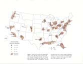
Figure
6. Busiest U.S.
Airports and High-Order Urban
Areas, 1983. Except for Las Vegas, Salt Lake City,and Memphis, all of the most heavily used
air hubs are in high-order urban areas. The high-order
urban areas, or conurbations, are daily commuter
areas with at least 2 million population, centered on one or more census metropolitan areas of
at least one million. Source: note 4. Air traffic data,
1983; population data, 1980.
(p.
12)
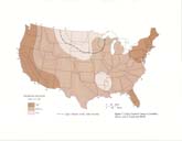 Figure
7.
College Students' Image of Livability. Source:
note 8, Gould and White.
(p.
13)
Perhaps
the steepest gradient, in many ways, occurs at the United States-Canada
boundary. To be sure, the border is open, friendly, easily crossed, and frequently crossed
by many who live and work near it. Yet, to cross it and remain for long, you have to
disentangle from one web of national history and geography and weave yourself into a different one.
The two histories and geographies overlap and entwine in many ways all along
the border. But they are recorded in separate sets of records —one set
linked north and the
other south, one set ultimately to Ottawa and the other to Washington. In the settlement and
development of the Upper Midwest and the Canadian Prairies, many broad parallels and
cross-linkages emerge. Yet the balance of binding
ties today shifts very sharply to Toronto,
Winnipeg, Calgary, and Edmonton at the Upper
Midwest's northern boundary. For most
Americans the mental map of climate ends there, too. Details of seasonal and
daily variety dissolve into a uniform misconception or
a blank. Canada's federal and provincial governments
work hard at educating Upper Midwesterners
about the warm, sunny summers north
of the border. For it has been hard to get Midwestern Americans beyond
the idea that central Canada is an icebox,
from where the coldest weather comes.7
The
External Image That Segregates
While
internal ties bind the region, an awesome national mixture of disinterest and puzzlement
has segregated it. You might guess that 95 percent of Americans view the region as uninhabitable, with a climate
suitable only for testing batteries, motor oil, and pick up trucks. Most of the
other 5 percent know better because they live here or they have
lived here. Migration data make it clear that many would like to return, and
many do. Business-executive
surveys rate the Twin Cities
at or near the top among large urban areas for
quality of housing, neighborhoods, recreation, government, education, and culture. I have
heard senior officials in Washington wax nostalgic
over times they spent in "those remarkable communities" of Bismarck or
Brookings, to name two. But those are the reactions
of people who have lived in the place.
And most have not.
The
region is a blank on the mental maps of most Americans. For better or worse, no popular
image or symbol takes shape. College students elsewhere do not spontaneously think
of it as a place to live after they graduate (Figure 7). Families approaching retirement
age do not hear of it as a place for enjoyment of their later years (Figure 8). In
media stereotypes wheat ranchers are from Kansas, not North Dakota or Montana. Cattle ranchers are from
Texas, never South Dakota. Carefully shirt-sleeved
decision makers ponder printouts in
the towers of New York, Chicago, perhaps
Houston or San Francisco, not the Twin Cities.
Outdoor recreation is pursued in the mountains, in the Southwest deserts, or on subtropical beaches, seldom in the Boundary Waters
canoe country or on the quiet lakes of the North Woods. To be sure, over
the years a jumble of names has shown through
the mist-for instance, the Mayo Clinic,
Burma Shave, Scotch Tape, Glass Wax,
Sinclair Lewis, Lawrence Welk, Bronco
Nagurski, Roy Wilkins, Mary Tyler
Moore, Hubert Humphrey, and the
characters of Lake Wobegon. But such
emissaries appear to be as accidental and unusual as a chilly day in the Sunbelt.
Frequently
the national media quote someone who says "the Twin Cities are an
excellent place
to live." Thus Minneapolis-St. Paul become a vague, inexplicable anomaly amid the wastelands, glaciers,
and boondocks. The personal and
institutional emissaries and the peculiar
reputation of the Twin Cities do as much to deepen the mystery as resolve
it. As a New York cab driver said to me,
"You got a ball club there. They
got to have a place to play. So what does the place look like? Yankee Stadium and glaciers?"
Momentary visions arise, but sooner or
later the emptiness closes in again on that part of the national mental map that yawns between
the Bear Paws and the Porcupines, the Skunk
and the Rainy. At least so it seems sometimes
from the heartland!8
Varied
Environments
In
fact, 6 million people do live in the primary region of the Upper Midwest, 8 million in
the banking region. They live in natural environments
with vivid variations from one part of
the region to another—environments which
do, indeed, have a lot to do with glaciers (Figure
9). Those different environments not only
offer the reality to fill the void that exists in so many imaginations, but also provide the stage
on which the real story of the region's settlement has unfolded.9
THE
FOREST ZONE
On
the east and west the region is framed by two of the great wooded regions of the United
States—the northern Great Lakes and the northern Rockies. The Great Lakes forest—the
North Woods to 40 million Midwesterners who live and work to the south of it
— shades the Upper Midwest
east and north of a line from Lake of the
Woods to the Dalles of the St.
Croix River, northeast of the Twin Cities, to north-central
Wisconsin.
(p.
14)
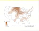
Figure
8.
National Image of Where Not to Retire. Source:
note 8, Boyer and Savageau. (Based on map
of
rated
retirement sites, 1984.)
(p.
15)
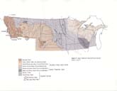
Figure
9. Upper
Midwest Natural Environments. Source: note 9.
(p.
16)

Cropland, partly improved pasture strewn with glacial boulders, and the ever-present forest
backdrop, in the northern Wisconsin countryside between the Twin Cities and
Wausau, are typical of the eastern part of the Upper Midwest. Photo by
author.
Today
the forest is a crazy-quilt. Each patch
is a grove dominated by one of many species-spruce,
pines, balsam, tamarack, birch,
aspen, oaks, maples, and other hardwoods.
In the brief autumn patches of a brilliant variety of reds, browns, and golds
flash among the evergreen, and for a
week or two the quilt becomes a
masterpiece. At that time, on a clear
late afternoon, it is worth the price of
a plane ticket to Duluth or Houghton just to see
the quilt in aerial panorama.
Each
patch has its story. In part the patches
reflect the stages in the botanical succession
as each particular piece of the forest recovers from its most recent cutting or
burning,
invades the derelict clearing of an abandoned
farm, or grows in the neat rows of a new plantation.
In part, also, the forest patches reflect
the random pattern of sand, clay, gravel,
boulders, and bog that make soil mapping on
these glacial moraine deposits a cartographic
nightmare. Disorderly heaps and terraces
and saucers of glacial material form the land
surface everywhere beneath the trees. But there are natural openings at the thousands
of lakes and ponds and a few openings, too,
where geologically ancient bedrock protrudes
as bald hilltops through the glacial drift.
Water
is in abundance. Dependable summer
rain and winter snow supply the moisture.
Cool summers reduce direct evaporation and the amount needed by growing
vegetation. As a result the subsoil is
moist. The lakes are full. Closely spaced, dependable streams meander
and tumble from lake to bog as they head
for Lake Superior, Lake Michigan, or the Mississippi.
(p.
17)

Ice-age glaciers scoured a deep trench for Lake of the Clouds and polished the hard, half-billion-year-old rocks that
surround it. A mixed forest of pine and northern hardwoods mantles the rugged terrain of the Porcupine Mountains, in Michigan's Upper Peninsula. Photo by author.
In
the northern part of the Great Lakes forest
zone, the land rises in massive waves toward
the great Canadian Shield. Made of some
of the oldest, hardest, and most mineralized rock, the Shield forms the high
ground of central
and eastern Canada. There the continental
glaciers of the ice age accumulated, and
from there they spread chaos south to what
is now the Ohio and the Missouri. The southern
edge of the Shield is in the Upper Midwest,
in the wilderness of the Boundary Waters Canoe Area and the Voyageurs National
Park of northeastern Minnesota. As the elevation
falls toward the south, only the higher
ridges of hard rock protrude through the
mantle of glacial deposits. Several of those ridges are the famous mineral
ranges - the Me-sabi and Vermilion of Minnesota; the Gogebic, straddling
the Wisconsin-Michigan border; and
the Copper, Menominee, and Marquette ranges
of Upper Michigan.
The
most impressive ridge is the great geologic
fault scarp that forms the north shore of Lake
Superior. Behind the clean pebble beaches
and headlands, the country rises a thousand feet or more to the north horizon. Offshore
a few miles the lake is nearly a thousand feet deep. Off the south
shore another ridge, nearly submerged, rises
faintly above the lake level to form the Apostle Islands. In summer
the deep, cold lake, towering ridges, and
rocky islands create anomalous narrow strips
of maritime environment in the heart of the
continent-always cool; with ample wind for
sailing; sometimes fog-shrouded; with a long, mild growing season that is
especially gentle for flowers of
forest and garden. In deep winter the scene takes on the character of the wildest coast of Lapland
—crashing waves amid driving snow
with a southeast wind, grotesque
giant ice curtains and stalactites, colorful pebble beaches encased for miles like souvenirs
in a sheet of ice laid exquisitely by breaking waves, days when arctic sea smoke
rises in whisps as far as the eye can see while the
open lake steams beneath subzero air blowing from somewhere near the North Pole.
(p. 18)

Nearly
1,000 feet deep a few miles offshore from this point, midway
betwen Duluth and the Canadian border, the open water
of Lake Superior combines with a subzero arctic gale to create a unique,
awesome midwinter scene. Photo by author.
The
other forest realm covers the western part
of the region. As you move toward the west,
it first appears in islands of ponderosa pine
on the great isolated earth crustal domes called
the Black Hills or the Big Horn, Bear Paw,
Big Snowy, Belt, and Crazy mountains. Farther
west the forest is nearly continuous in the
corridor of crustal upheaval named the Rocky
Mountains, from Yellowstone to Glacier Park and beyond. Most of the forest
lies above the 4,000-
to 5,000-foot contours, up to the
timberline at 9,000 to 10,000 feet. In that range
of altitude, both moisture and summer heat
are adequate. Not only is the forest more dense
and tall in the main ranges of the Rockies,
but also it is more varied. West of the continental divide stands of douglas
fir and lodge-pole pine
turn your thoughts toward the Pacific
Northwest. Winter snow, spring and autumn
rains are more reliable, thanks to more direct
exposure to moisture from the Pacific.
The
highest water yields in the region come from
the mountain forests and the barren
jagged peaks and snowhelds above them. Most
of the water pours out in torrents during the spring melt and spring
rains. But some soaks in to saturate the
forest litter and rocky slopes, then seeps out gradually during the warm
season. All of it feeds the clear upper reaches
and the muddier, lower main stems of famous
tributaries of the Missouri and Columbia. Below the forest, grassy benchland
slopes to the Great Plains on the east
and into the broad valleys between the
main ranges — especially the
spectacular trenches of the Bitterroot and Flathead. In the classic western
settlement pattern, cities, towns, and
irrigated ranches lie in the wider
valleys. Old mining towns and locations
string along certain canyons. Logging roads and scenic highways lead to camps
and cabins of
exurbanites and to the edges of wilderness
preserves in the mountain forests.
(p.
19)
THE
CROPLAND CORRIDOR
The
wide plains between the two forests are
the agricultural realm of the Upper Midwest.
The heart of the agricultural country is in the
prairie-glacial drift plains corridor. It trends
southeast-northwest from northern Iowa
to northern Montana. That corridor shares, with
the rest of the North American Middle West and
Great Plains and perhaps three or four regions on other continents, the world's finest
upland soil resource for modern farming technology. The land was mostly treeless
prairie at the time of white settlement; hence nature spared farm settlers
the costly work of clearing it. The
soils are formed on deep, fresh glacial
deposits, generally high in soluble mineral
plant food. Deep, dense roots from millennia
of prairie grass growth made the soil initially
high in organic matter and nitrogen. Though
a few boulders remain, not yet decomposed from glacial times, the material is
mostly a thick blanket of clay, loam,
and silt.
But
some important differences emerge within
the corridor. South of roughly the latitude of the Otter Tail River in
west-central Minnesota
and the Sheyenne in southeastern North Dakota, the growing season is long enough
for grain corn, and soybeans. Eastward
from the wide, level valley of South Dakota's
James River, the spring rains are ample
and fairly dependable. Summer rains are fickle
but adequate in most years. This warmest,
best-watered part of the prairie-drift plains
forms the Upper Midwest's part of the American
Corn Belt and the richest part of the Upper
Midwest agricultural base. Nature boosted
the settlers there to a head start, and subsequent generations of farmers have parlayed
their inheritance from the pioneers.
North
of the Corn Belt, a sizable part of the cropland
corridor is one of the most remarkable
of legacies from the ice age, the Red River Valley.
Of the great lakes ponded against the edge
of the retreating glaciers in central Canada
10 millennia ago, the greatest was Lake Agassiz.
The lake was named long after its demise,
of course, for the Swiss-Bostonian naturalist
Louis Agassiz. It covered a large part of what
is now eastern North Dakota, northwestern
Minnesota, and Manitoba. It rose to the height
of a divide along the present Minnesota-South
Dakota boundary and spilled over the
divide, southeast down a mile-wide trench now
occupied by the Minnesota River Valley. When
the ice finally disappeared, the lake emptied
northward through Hudson Bay to the sea. The
vast lake floor, mostly clay and flat as
a pancake, was then exposed to the sky and quickly
covered with a carpet of prairie. And so it lay until large-scale white
settlement began in the 1870s. Two brief, catastrophic events
in the long history of the earth have created
today's landscape there: the melting of the last ice sheets and the nineteenth-century spread
of European people. From the air today you see a fantastic landscape of
unbroken, flat, checkerboard fields. In summer the fields are square miles of wheat,
square miles of potatoes, square miles of barley, square miles of oats
or blue grass or sugar beets. The continuity
and scale of the checkerboard overwhelms all
but the larger urban centers in the landscape,
while it sustains them as thriving nodes in
the regional economy. Though smaller and less
moisture-retentive, the plain along the James
River through South Dakota is the second
of these two major islands of flat land on the
rolling prairie.
West
of the Red and James valleys the climate is drier. Rains fail occasionally in
spring, frequently in
summer. The climatic break comes
near the meridian of 100 degrees west longitude.
The Hundredth Meridian is the classic
boundary of the semiarid West in much of
our literature and official lore. Farmers near Lawrence
Welk's hometown, southeast of Bismarck,
live close to that meridian. They could show
you prairie land shaped by the glaciers that
is just as smooth as much of the Corn Belt. But their reliance on wheat and barley rather than
corn reflects their lesser confidence in the moisture
supply. As the glaciers pushed southwest into drier, warmer country, they
thinned and stalled on long, high ridges
that trend northwest-southeast on the plains. The longest
and highest of those —the Missouri Coteau
—still carries the name the French explorers gave it. Chaotic small hills,
intervening shallow prairie potholes,
and boulder fields pock the surface.
Those are the features of glacial
moraines, where the glacier's edge stood vacillating
for hundreds of summers. The rate of
ice advance equaled the rate of melting at the
front; as a result the glacier just kept hauling in and dumping load after
load of dirt and rock along the same line. Today the potholes fill
to the brim in a wet spring. But during perhaps
half of the summers in living memory, drought and evaporation have left many of
these low areas as mere flat white beds of cracked
alkaline mud. Nineteenth-century school
geography maps used the label "Region of
Salt Waters." That was the way the area looked
to surveyors who saw it during the 1860s.
But the larger, wetter potholes provide way
stations for tens of thousands of waterfowl
on the plains flyway between the Gulf of Mexico
and their Canadian nesting grounds. North
Dakota farmers on the Missouri Coteau could
explain how they avoid potholes and the worst
boulder fields, leaving those areas for grazing
and waterfowl habitat.
(p.
20)

Outbuildings
make up a large livestock feeding operation in south-central
Minnesota in the early 1980s. The black soil evolved
beneath natural prairie grasses that mantled much of today's
Upper Midwest cropland corridor before white settlement.
Trees in the picture are all planted shelterbelts around the farmyards.
Photo, Frederic Steinhauser.

In
the drier wheat country west of the Hundredth Meridian, strips
may be cropped in alternate years to conserve moisture on
the gently rolling uplands. Where river valleys are incised into the plains, grass and sage sparsely mantle the sharp ridges,
cedars pock the rocky ledges, and cottonwoods and box elder
follow the narrow draws. This view is north from the breaks of the
Yellowstone River in eastern Montana. Photo by author.
(p.
21)

This
southeastern Minnesota valley, west of LaCrosse, Wisconsin, lies in the
stream-dissected, unglaciated part of the transition
zone between the cropland corridor and the Upper Great
Lakes forest. Steep, wooded valley walls separate the fertile, rolling ridgetops
from the rich bottomlands several hundred feet below. Photo, Frederic
Steinhauser.
West
of the country around Havre and Great
Falls, the prairie-glacial drift plains broaden
and flatten again in an area Montan-ans call the Triangle, between the Missouri,
the
Rockies, and the Canadian border. This is the
type locality of the famous warm chinook winds
of midwinter. Rainfall and snowfall are a
little more reliable than on the plains to the east.
The Sun and Marias rivers, and numerous swift creeks, bring irrigation water
from the
neighboring mountains. With more moisture
and milder winters, ranchers in the Triangle
grow nearly half of Montana's wheat.
THE
TRANSITION ZONES
A
narrow transition zone separates the main
cropland corridor from the Upper Great Lakes
forest realm. The transition zone is widest
and most unusual—for the Upper Midwest-southeast
of the Twin Cities, through southwestern
Wisconsin and northeastern Iowa. By
chance the ice-age glaciers bypassed this
area. As a result, splashing rain and streams
have had more than a hundred million years
to carve its surface into treelike networks of
valleys and intervening ridges. The land is unglaciated
and stream-dissected. The upland fields,
on fertile but thin soil, command panoramic
views across waves of high, rolling ridge
tops and deep ravines. Clean limestone cliffs
and intervening steep slopes of rock waste
form the valley walls. Rich hardwood forests
darken the north-facing bluffs and ravines, while cedars dot the
otherwise open goat prairies on drier
southwest-facing slopes. On the bottoms the rich floodplains and terraces
support cropland, and the tributary rivers
wind rather steeply toward the Mississippi.
On the western, drier side of the transition zone, before agricultural
settlement, prairies covered the ridgetops
as well as the south-facing slopes. Scattered groves interrupted
the tall grassland. But on the less drought-risky
eastern edge of the zone, only scattered
openings of prairie interrupted the dominant
woodland. The lovely islands of prairie and grove inspired scores of place-names
across the transition zone in the Upper Midwest.
(p. 22)
 Rough, lake-studded glacial moraine land in the Park Region of west-central Minnesota is typical of much of the Dairy Belt, on the northeastern margin of the Upper Midwest's cropland corridor. Photo by author.
In
Minnesota, from the southernmost lake district
at Albert Lea to the most northwesterly lake
district around Detroit Lakes, the forest-to-prairie
transition zone lies on the remarkably varied surface of the Upper Midwest's most
extensive and roughest glacial moraines. From the tops of 100- or 200-foot
knobs, early explorers
could see for miles across a lush, rolling
compage of hills, lakes, prairies, and woodlands.
For good reason, they called it the Park
Region. The name still fits the landscape, although
the prairies are now pastures or fields.
These transition areas are the historic heart
of Upper Midwest dairy farming.
North
of Detroit Lakes the big moraine loops
eastward into the forest zone. But the forest-to-prairie
transition zone continues northward
across the international boundary, along strings of low, sandy beach ridges that
once formed the shores
of great Lake Agassiz. Groves of aspen and openings of prairie, at the time
of white settlement, made the transition between
wooded beach-ridges among vast bogs
in the forest zone to the east and the flat prairies
of the Red River Valley to the west.
Another,
very much wider and very different transition zone spreads westward from the
Missouri. South Dakotans call it West River
country. North Dakotans call it the Slope and
might tell you it's the section of the state with
rattlesnakes. Summer tourists speeding from
Chicago to the Black Hills get a feeling that
this is where the West begins.
(p. 23)

A
midwinter view looks southwestward across the wide Missouri
in south-central South Dakota. The stream's crevassed ice
cover separates the smooth veneer of glacial deposits, black prairie
soil, and checkerboard of corn fields on the east side from
West River ranching country. To many travelers, this is where
the West begins. Photo by author.
The
general elevation begins to rise subtly from
the Missouri toward the Black Hills, Big
Horns,
and Rockies. Meanwhile, like the Upper Mississippi Valley below St. Paul, the trans-Missouri
country was mostly beyond the reach of the
ice-age glaciers and their smoothing
veneer of drift. The face of the land reflects
the work of the master rivers that flow from
the mountains and Black Hills to the encircling
Missouri. Their names are legendary in the West-the Yellowstone,
Musselshell, Big Horn, Powder, and Tongue,
the Little Missouri, Cheyenne, and White, and the smaller Knife,
Heart, Moreau, Grand, and Bad. Except
for the Yellowstone, these are slender streams, for they drain the driest
part of the northern Great Plains. But
without harassment by continental
glaciation, there has been time for a quarter-million hundred-year storms to pound and erode
their watersheds. The result is a series of
deep, wide, rugged trenches radiating from the high country toward
the Missouri, and along the Big Muddy. Valley
walls are generally covered with prairie and
sagebrush. The
surface is harsh but resembles velvet in shadowy panorama when the
sun is low. In a few spectacular places, the soft, colorful, geologically young
bedrock has washed
easily and has seldom stabilized long enough
for the plant cover to take hold. Those are
the Badlands. The rivers are widely spaced,
for it takes a lot of land to catch enough water
to make a river in this dry country.
(p.
24)
Gently
rolling plateaus project toward the Missouri between the breaks of tributary valleys.
With no glacial deposits to mask them, local
buttes and pine-edged escarpments rise above
the plateaus. They are landmarks on always distant skylines. To the early
scouts they first intimated the mountains beyond the horizon
to the west, and later they provided guideposts to wagon trains on the trackless
prairie. Today you
might get the local names for
those features from ranchers, as you survey
the hve-square-mile expanse of each one's wheat
fields or rangelands.
Global
Forces —Natural and Human
The
active powers of nature have created this
varied stage for Upper Midwest settlement.
The stage is the product of global flows of
air, water, and the earth, itself. The global flow
of air makes a dramatic and dynamic climate
today (Figure 10). Daily television and newspaper
maps tell that story. Two of the three most
frequent positions of the atmosphere's west-to-east jet stream across North
America converge from Alberta and Colorado
to the Great Lakes. The low pressure centers
that follow those routes swing their continuous
procession of fronts, with accompanying temperature changes, cloud, and
precipitation, across the Upper Midwest.
Those
converging storms and jets draw air from
three of the world's most contrasting sources
across the region's forests, fields, lakes, and settlements. One source is the Canadian
Arctic. Air from that source is cool in summer,
frigid in winter, and always antiseptically
clear, to let the northern lights, stars, and
sun shine brighter. A second source is the Tropical
Atlantic. Moist air streams from there westward
across the Gulf of Mexico, north up the
central lowlands, and into the passing lows
and fronts. Storms lift it to form the mountainous
thunderheads of summer and the leaden,
layered clouds of winter. Then the storms
wring from those clouds the downpours, blizzards, and drizzles that water the land.
Those tropical maritime airstreams often reach the Upper Midwest at the surface east of the Hundredth
Meridian in spring and summer, but west of
the Hundredth Meridian only occasionally
and mainly in the springtime. They
seldom reach the region at the surface in winter but spread over it aloft to
produce most of the winter's clouds
and snow. The third source is the dry
western plateau country, between
the Rockies and Sierra-Cascades. That source
is cool in winter, hot in summer, and always dry. Passing storms draw its dry air into the
Upper Midwest frequently as far east as the Hundredth Meridian, less
often into the eastern prairie region as far
as Minnesota and Iowa. In winter
continental incursions are the warm chinook winds of the High Plains and the
less frequent thaws of the eastern areas. In
summer they are the spells of hot winds which
bring searing temperatures and, if they persist long enough, wilt sapling
trees and turn fields to dust. Only over the
high mountain country do these air masses give up some of
their meager water content, from sheets of winter clouds and
summer-afternoon thunderheads.10
Thus
the global wind system today differentiates
the region into a northeastern province
of cool, moist summers and cold, snowy winters;
a subhumid prairie province east of the
Hundredth Meridian; a semiarid short-grass prairie province west of the Hundredth Meridian; and the moist high
country of the mountains and Black
Hills. In the ice ages of the
geologic near-past, a similar global wind system prevailed. But temperatures fell enough that in the cool, snowy northeastern province
the snow accumulation in the longer winter became more than the sun and
rain could melt during the shortened summer.
For thousands of years the
accumulation deepened, compacted, and began to spread. The spreading
sheet stalled when it moved south of
the major jet streams into realms of warmer or
drier air, or both. Thus the same location in the
global air flow that creates Upper Midwest weather
patterns today created the glacial patterns
that left their imprint on so much of the land in the ice age.
The
global flow of water takes the moisture
delivered from the ocean surface by the atmosphere
and returns it to the oceans down the
Missouri and Mississippi, the Columbia, the
Red, and the Great Lakes (Figure 11). But in the interim, like the flow of air,
the flow of water differentiates the Upper Midwest into contrasting
realms. Rain water and snowmelt partly
soak into the soil, partly run off directly to
the nearest stream. The soak-in first nourishes the cover of crops, range, and
forest. Whatever remains fills the
ground water reserve and seeps
through springs to the streams as
indirect runoff. If none remains, then no springs or streams flow in the
long periods between annual spring melts or
infrequent severe summer storms. If
there is not enough soak-in to support
a forest, there is no forest. Thus the vegetation cover and the stream flow reflect the rainfall, snowmelt, and water budget of
the region.
(p.
25)
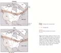
Figure
10. The
Upper Midwest's Position in the Flow of Air
across North America. Low pressure centers
that follow the northern paths of the atmosphere's
jet stream swing their procession of fronts across the Upper Midwest, with
accompanying clouds, rain, and winter snow. They draw air from three of
the world's most contrasting source regions.
Source: note 10.
(p.
26)
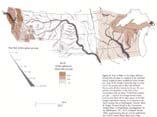
Figure
11.
Flow of Water in the Upper Midwest. Runoff
from the land is a measure of the sustained annual supply of water available for
direct human use.
Some of the runoff is stored for days or centuries
in the ground and in lakes and wetlands. Rivers
carry all that remains to the sea. For comparison,
municipalities in the Twin Cities metropolitan
area use about 75-100 billion gallons per year
— equal to the average annual runoff from
an area about 30-35
miles square in the Mississippi
headwaters country, or 4-5 percent of the river's
average flow at Minneapolis. Sources: Mark W.
Busby, "Annual Runoff in the Coterminous United
States," in Hydrologic
Investigations Atlas
(Washington, D.C.: U.S. Geological Survey, 1966);
supplementary data for several small basins from
USGS annual Water
Resources Data.
(p.
27)

In
early spring the Baptism River pours 20,000 gallons of water
per second, from a 1,000-square-mile drainage basin in northeastern
Minnesota, over the escarpment along Lake Superior's north shore. Photo, David
Borchert.

In
late spring the Powder River brings a few hundred gallons of water per second
from a 20,000-square-mile basin on the Great Plains. Pine-edged buttes rise
above the dry grassland on
the horizon in southeastern Montana. Photo by author.
(p.
28)

In
a dramatic expression of the conjuncture of global forces, the
forested Rockies rise above the treeless plains on the region's western
periphery in central Montana. Photo by author.
The
cool, moist northeast and the western high
mountains are also the realms of forests and
lakes and the sources of large, dependable rivers.
The subhumid, somewhat drought-riskier
prairies east of the Hundredth Meridian
are also the source of smaller rivers and a land of fewer lakes. The semiarid western plains
were clothed in only a shortgrass prairie; today they support only more
drought-resistant crops and send out only meager, widely
spaced rivers.
Even
the gradual flow and heaving of the earth's
crust are reflected in the giant folds, faults, domes, and basins of the western
mountains; in the
massive subcontinent of ancient
rock that forms the Canadian Shield; and in
the mineral veins injected into fissures during
eras of great crustal disturbance (Figure 12).
Crustal shifts are also reflected in the broad
basins, filled with miles-deep layers of sedimentary
rock, which lie beneath the plains of
Dakota and eastern Montana. Some of those rocks are oil- and coal-bearing and
provide the large
reserves of the Powder River, Knife River,
and Williston basins.
People
have set the stage and changed the scenes
with comparable drama —and also through
processes as inexorable and evolutionary
as nature's. Suppose you were to talk with
the people whom you inevitably would encounter
if you were to go out to look at the different
natural environments of the Upper Midwest.
Loggers in the northern Wisconsin forest
might talk about their forbears who were
Chippewa Indians living in the region when white explorers, missionaries,
traders, then loggers, townspeople, and
farmers arrived. Taconite mill workers on the Mesabi Iron
Range could tell you about their Finnish forbears
who migrated to the Lake Superior district
when the Czar was imposing a tightening
tyranny on their homeland in the early 1900s.
(p.
29)

Figure
12.
Upper Midwest Mineral Resources. The deposits reflect the history and location
patterns
of the gradual flow, heaving, and fracturing of
the earth's crust through geologic time. Sources: James
Turnbull, Coal
Fields of the United States
(Washington, D.C.: U.S. Geological Survey,
1960), sheet 1; Oil
and Gas Fields of the United
States (Penn-Well Publishing Company, 1982),
note 9, Gerlach.
(p.
30)
Farmers
in the Iowa Corn Belt might tell you
about their German grandparents; a Red River Valley family, their Norwegian and French
Canadian backgrounds. One family on the
Missouri Coteau in North Dakota could talk
about the Russian-German settlement there
in the 1890s, and another in the Montana ranching
country might recall their great grandparents'
stories of their trek from Missouri
after the Civil War. An exurbanite couple in
a Montana mountain cabin might discuss their
real estate business in California and their
parents' immigration from Italy to New York.11
The
varied settlement map of the Upper Midwest
reflects flows of people whose individual
decisions have been motivated and constrained
by massive migrations, social and political
movements, conflicts, famines, and tyrannies
in many corners of the world. At the same
time, of course, their individual decisions
and actions added up to these very same movements,
migrations, and conflicts. There-suit
has been a continuing avalanche of events with
tumbling momentum and lives of their own.
Mean while-within the world's established
networks of settlement, transportation, and
communication-streams of information, inventions,
goods, and capital constantly flow to
and from the region and within it. Those flows continue to change the maps of
the region's population, employment, income, and
connections. The environment is dynamic.
The region is a product of the convergence of
global natural and human forces.
Little
more than a century ago the Upper Midwest
region was an embryo. Most of the land
lay beyond the American frontier. In a century it became a prosperous, integral
part of the world
economy. The region today is a complex
network of farms, small towns, cities, metropolitan
areas, and connecting routes.
So,
those who pose serious questions about the
region seek to understand that remarkable
transformation. What accounts for the
Upper Midwest's location, shape, and look?
What has been the anatomy of its initial development? Of its adaptation to dramatic national and worldwide
changes? Why and how much has the region's identity persisted amid
so much change?
One
way to try to comprehend the process of
change is through geographical snapshots of the region's settlement at different
times. Three times are
especially critical. Around 1870
American Indians sparsely occupied the land.
The white invasions of the Upper Midwest on a
large scale had just begun. The growth of the
United States as a major steel producer
and the steel rail era of transcontinental railroad building had just begun.
By 1920 the occupation of the region
by whites was essentially complete.
The Northwest Empire had been
created. The era of the automobile, airplane, cheap oil, and electronic communication
was just emerging on a large scale. In
the 1970s and 1980s, products of the era
that began around 1920 are in place: industrialized
agriculture, metropolitan settlements,
highway-air-electronic networks. The empire
has become in many ways a neighborhood
in an increasingly unstable, intense, worldwide
circulation system.12
In
the 1980s we are now entering a stage of unprecedented
growth of awareness of the worldwide system and its complexity.
Those three widely separated times frame two major epochs for understanding the
Upper Midwest: an epoch of development and rapid population growth between 1870 and 1920, and an epoch of great adaptation and economic growth between 1920 and the 1980s. The two periods, in sequence, also provide some background for us to think about further change and adaptation in another period,
beyond the 1980s.
